
CASE STUDY
Download PDF
KEY RESULTS
Satlantis provides high-resolution Earth-observation imagery for environmental and industrial monitoring. As demand for higher resolution and wider coverage increased, the company faced a critical constraint: raw image data volumes exceeded available onboard storage and downlink capacity.
Conventional “visually lossless” compression reduced file sizes but discarded subtle pixel-level information essential for scientific analysis and AI-based applications. To scale imaging capacity without new hardware or additional satellites, Satlantis needed a solution that significantly reduced data volume while preserving full image fidelity within strict space-mission constraints.
In April 2024, Satlantis upgraded its GEISAT precursor satellite with Dotphoton’s Jetraw Core via a remote firmware update. The software-only integration increased the amount of usable image data the satellite could capture and downlink — without any hardware changes. Satlantis can now acquire and transmit 3–4× more image data per mission while preserving the full quality of raw image data, reducing the impact of downlink limitations and improving mission efficiency.

"This collaboration with Dotphoton will increase the throughput of our very high-resolution data acquisition and belongs to our commitment to constantly upgrade the performances of our missions for our customers through innovation and operational efficiency."
— Juan Tomas Hernani, CEO of SATLANTIS
Using Jetraw Core, Satlantis increased data throughput, achieving a 300–400% increase in image acquisition. By significantly reducing image file sizes, Jetraw Core lowers bandwidth requirements and enables faster and more cost-effective downlink. As a result, the GEISAT satellite can now download up to 55,000 frames per day, compared to approximately 15,000 frames previously.
The increased data throughput enabled a significant expansion of daily imaging coverage. GEISAT increased coverage from approximately 54,000 km² per day to 175,000 km² per day — a 3.5× increase. This expansion substantially enhances Satlantis’ Earth-monitoring capabilities by enabling broader geographic coverage within the same mission framework.
By transmitting more usable data per downlink, Satlantis now emits approximately 3× less CO₂ per square kilometer of satellite imagery. This represents a significant improvement in the sustainability of its operations relative to the initially planned emissions budget, aligning with Satlantis’ broader objective of delivering satellite data in a more environmentally sustainable manner.

"We continuously push the boundaries of innovation in Earth observation, and integrating Jetraw’s advanced compression technology into our GEISAT innovative mission is another example of this commitment. This collaboration strengthens our ability to set new industry standards, ensuring that SATLANTIS remains at the forefront of sustainable, next-generation space imagery, empowering the future of Earth monitoring."
— Aitor Conde, Chief Technology Officer, SATLANTIS
Jetraw Core is an on-device solution for camera and instrument manufacturers, optimising image performance and user experience without compromising quality.


Headquarters
Leioa, Spain
Founded
2013
Instruments
GEISAT satellite with iSIM-90 VNIR/SWIR camera; 2 m and 5 m resolution VNIR/SWIR imaging; 13 m resolution for methane products
Imaging technique
Earth observation; infrastructure monitoring across oil and gas, biogas, landfills, and power infrastructure; methane emissions detection
Partner

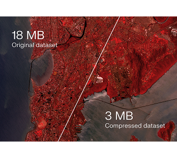
Image acquired in 2024 on GEISAT and compressed with jetraw core.
Image over India (18.6744131670765, 73.47714949631047)
Learn more
Book a 30-minute discovery session. We'll walk you through how Jetraw fits into your imaging workflow.
Book a demo
We use cookies to enhance your browsing experience and analyse site traffic. By clicking "Accept all" you consent to our use of cookies. Manage preferences