
EARTH OBSERVATION
Jetraw Core compresses raw satellite imagery 6:1 in real time. More usable images per mission. Lower infrastructure cost. Training data your AI can trust.
Selected clients and partners






THE CHALLENGE
JPEG2000 and CCSDS standards were designed before AI workflows became central to Earth Observation. Their visually lossless variants achieve compression by discarding the subtle signal information that the human eye can't perceive, but that modern AI models depend on. Your pipelines end up making a constant tradeoff between what you can transmit and what your AI can use.
01
High frame rates and sensor resolutions push onboard hardware to its limits. You sacrifice frame rate or resolution, not both.
02
Ground station windows are finite and expensive. Transmitting full uncompressed data at scale is not viable.
03
Full-resolution raw archives multiply infrastructure costs on the ground and in the cloud.
04
Visually lossless compression removes information the human eye cannot see. AI can. That signal loss compounds across training sets and degrades model performance.
HOW JETRAW CORE COMPARES
Most popular compression standards in use today were built for a different era. Jetraw is built for the demands of AI-driven Earth Observation pipelines.
| JPEG2000 | CCSDS 121.0-B | CCSDS 122.0-B | CCSDS 123.0-B | Jetraw Core | |
|---|---|---|---|---|---|
| Designed for | General imagery | Any telemetry data | Image data onboard spacecraft | Multispectral / hyperspectral | Raw image data for mission-critical AI |
| Compression mode | Lossless and lossy | Lossless | Lossless and lossy | Lossless and near-lossless | Two-stage: calibrated noise preparation + lossless |
| Compression ratio | 2:1 to 4:1 lossy | Less than 2:1 | 2:1, possibly slightly better | Around 2:1 near-lossless | 5:1 to 10:1 depending on scene |
| AI suitability | Lossy introduces artefacts harmful to AI | Limited ratio, not suited for large datasets | Artefacts impact ML accuracy | Near-lossless degrades subtle signal | Tailored for AI. No artefacts, no bias, no signal loss. |
AI-READY AND FUTURE-PROOF
As AI models become more capable of extracting value from subtle sensor-level signal, the quality of your compressed archive determines what your AI can and cannot learn. Jetraw Core preserves that headroom today, so your data pipeline does not become the bottleneck tomorrow.
JETRAW CORE
Jetraw Core integrates into your pipeline at the point of highest value: onboard the satellite before downlink, or at the ground station and cloud. The same algorithm, the same quality guarantees, the same compression ratios.
HARDWARE
Integrate directly into the satellite payload. Compresses onboard before downlink. Low power, low latency, high throughput.
Speed
Up to 6.4 Gpx/s (32-pixel parallel)
Throughput
On-line real time compression
Latency
~60 clock cycles
Resource usage
5000 LUT (1px) -> 120,000 LUT (32px)
Integration
Encrypted VHDL sources, AMD/Xilinx and Altera
SOFTWARE
Deploy at the ground station or in the cloud. No hardware changes required. Callable from all major languages.
Speed
6.2 GB/s (Intel i9 14900K)
Platforms
x86_64, arm64
Languages
C, C++, C#, Java, Python
OS
Windows, Linux, macOS
Integration
DLL, CLI application
DATA QUALITY GUARANTEES
No artefacts
No blocking
No ringing
No banding
No aliasing
No loss of detail
Optimised for TDI signal recovery
CMOS, CCD, Bayer, multispectral, hyperspectral
Any uncompressed RAW format input
TYPICAL INTEGRATION TIMELINe
Step 1
Intro meeting
Confirm interest. Optional NDA signing.
Step 2
Discovery session
Discuss needs, requirements, and feasibility.
Step 3
Cost estimate
Preliminary project estimate based on discovery.
Step 4
Deep dive
In-depth technical discussion, customised roadmap.
Step 5
Integration agreement
Commercial and technical agreement. Ready for blast off.
CASE STUDY
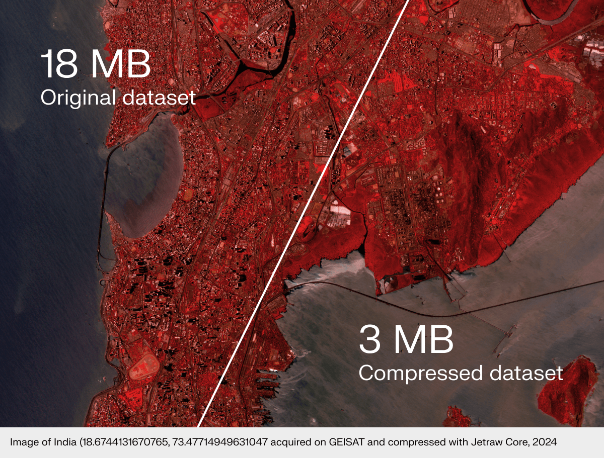
Onboard storage and downlink capacity had been the limiting factor on every Satlantis mission. In April 2024, they integrated Jetraw Core into the GEISAT Precursor satellite via a remote firmware upgrade.
The satellite now captures and downlinks 3 to 4 times more usable image data per mission, with full pixel-level fidelity preserved and a 3x reduction in CO2 footprint.
Read the full case study →“Collaboration with Dotphoton will increase the throughput of our very high-resolution data acquisition and belongs to our commitment to constantly upgrade the performances of our missions through innovation and operational efficiency.”
Beyond compression: for teams building satellite AI
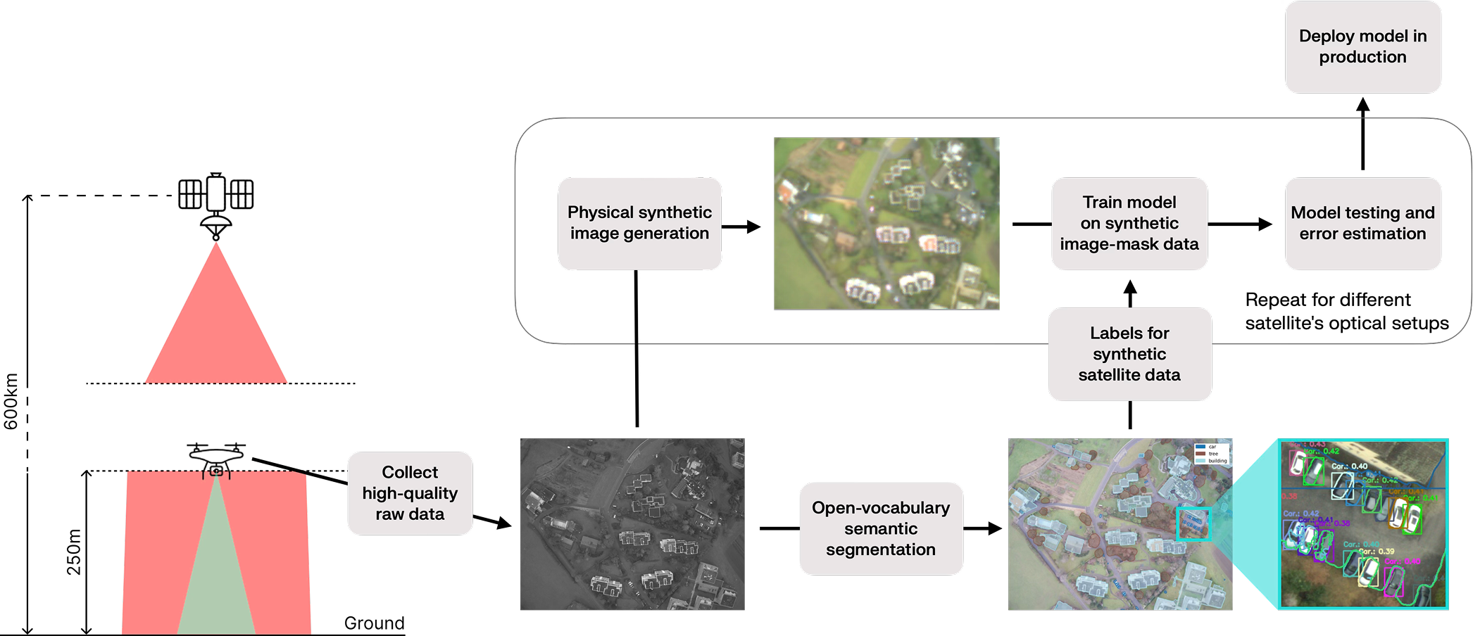
Datasets and pipelines are typically locked to specific sensors and acquisition setups. When mission conditions change, teams must restart data collection, labeling, and training. Our adaptation framework breaks this dependency by decoupling data from hardware.
How it works
Model the source sensor
Analytically remove the source camera’s acquisition to recover a sensor-independent radiance map of the scene.
Extract a reusable scene representation
The recovered radiance is hardware-agnostic — reusable across any target sensor without re-collecting data.
Synthesize target sensor data
Apply the forward model of the target sensor to synthesize imagery matching its real pixel distributions — optics, motion, noise and all.
What this enables
High-accuracy auto-labeling
Label drone data with foundation models, then remap labels to synthetic satellite imagery.
Early satellite optics evaluation
Assess whether an optical setup meets AI accuracy requirements before hardware is built.
Payload transition without relabeling
Migrate AI models across sensor generations or vendors when payload or orbit changes.
Pre-launch feasibility studies
Run in-silico analysis and provide accurate quotations before satellite launch.
CLIENTS AND PARTNERS
From high-resolution Earth Observation satellites to ground segment infrastructure, Jetraw Core is deployed where data quality and pipeline efficiency are mission-critical.
“There’s a paradigm shift from raw data delivery to information delivery. But those daily petabytes come at a high cost. Dotphoton preserves the image quality of our data while attaining high compression ratios, which was only possible with high information loss in the past. This allows storing full information, and processing it faster.”

Roberto Camarero
Onboard Payload Data Processing Engineer, ESA
Get started
Tell us about your satellite, your pipeline, and your data volumes.
We will assess the fit and walk you through a typical integration in one conversation.
We use cookies to enhance your browsing experience and analyse site traffic. By clicking "Accept all" you consent to our use of cookies. Manage preferences